October 02, 2020
Reflection: Geodesign know-how enabled student to thrive during internship
By Lara Garcia, Penn State MLA and Geodesign Certificate candidate
When professors at Penn State mentioned the opportunity to enhance my master’s degree in Landscape Architecture by also pursuing a Geodesign graduate certificate, I got excited about it because of my early understanding that it would be somewhat related to the regional planning field. I understood that we are living a moment of a critical review of past planning practices, and there was an active need for a feasible participatory method. From my first introductory course in geodesign, I realized that geodesign stands as an effective collaborative framework to reach solutions on social, environmental and economic demands. It does so because it successfully bridges designers, scientists and stakeholders to analyze the scope of geographical problems carefully, and then explore evidence-based decisions by evaluating optimal future scenarios. This helps to assess whether to keep a “business as usual” approach or opt for change.
For my future career, geodesign offers recognition that there are often conflicting views on how communities should be forged. Therefore, there is an urgent need to air and discuss those contradictory perspectives to reach the grounds of consensus assisted by relevant data and science. I have been excited to learn how geodesign supports those discussions by leveraging in-depth problem analysis, different stakeholder values and data to back up evaluation and decision models.
In February 2020 I attended the Geodesign Summit in Redlands, CA. This further opened my eyes as I got a sense of how diverse the geodesign practice is—from resilience planning for vulnerable coastline communities, to research on the potential of developing car parking areas to meet housing demands. Witnessing all those inspiring projects and having the opportunity to talk with practitioners/speakers lifted my spirits to keep pursuing a career that can positively impact this challenging world.
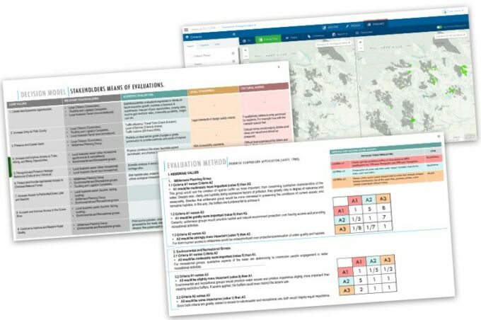
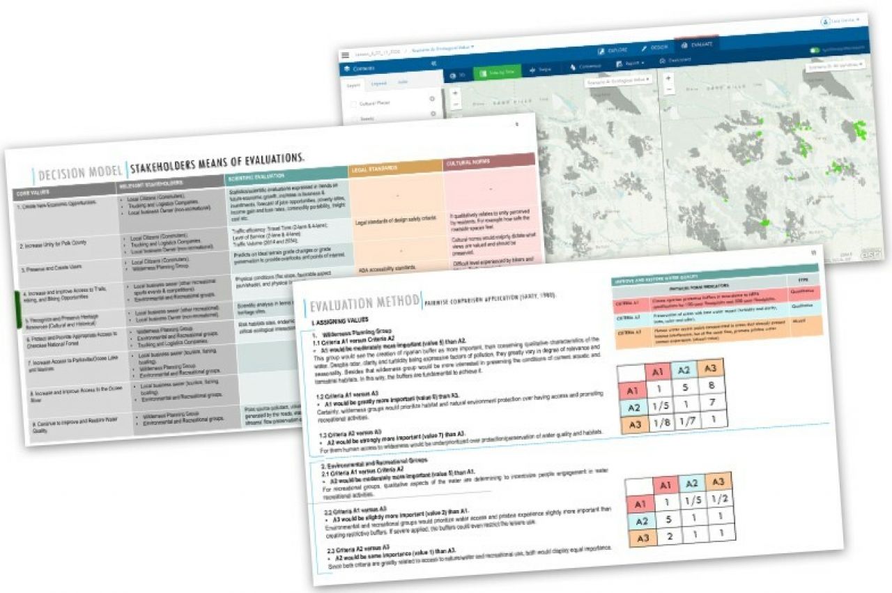
In the summer of 2020 I was fortunate to have a unique learning experience during my internship at Esri. I was assigned to work with the State and Local Government Services team. I participated in an exciting wide-reaching project to create a Regional Data Platform (RDP) for the 197 communities that make up the Southern California Association of Governments. This project aims to facilitate dynamic cooperation and collaboration among regional organizations, local planning agencies and stakeholders, while providing a more streamlined process for data sharing to enhance planning at all levels. It is a forefront vision of how appropriately organized and presented technology can enhance communication among different governmental levels and increase agencies' transparency and community outreach. I am also being exposed to numerous Esri solutions, such as ArcGIS Online, ArcGIS Hub, GeoPlanner for ArcGIS and ArcGIS Urban. Learning the tools and getting a glimpse of how these should enhance and translate planning workflows will solidify my future practice. Learning geodesign, coupled with this experience and these dynamic, digital tools, has enlightened me on new professional perspectives for future design and planning practice.
Supervisor Reflection
Penn State MLA alumna Caitlin Smith was Garcia's supervisor during her summer internship, and says Esri benefitted greatly from her "skills, energy and keen perception of the synergy of data and design."
Lara’s training in geodesign at Penn State prepared her to be a versatile and vital member of our team during her internship with Esri this summer.” – Caitlin SmithSmith noted that Garcia configured several prototype applications for community planning and resident engagement as part of the RDP project. "Her ability to bridge the worlds of spatial data, analytics and GIS with strong design skills has made her contributions not only unique and insightful, but also beautiful in a way that facilitates understanding, inspires engagement and fosters clear communication. For transformative projects such as this one, which involve multiple stakeholders, influence multiple systems and rely on data to drive the design of future communities, we need more minds shaped by geodesign education."